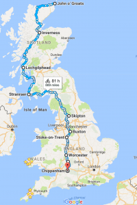
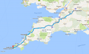
Our current plan is to cycle from JOG to Chippenham in Wilts in 22 days, averaging 45 to 50 miles per day. (The actual route is longer than shown on these Google maps.) We’ll have a week’s break to attend a wedding, then will head from Chippenham to Lands End, taking a leisurely 8 to 10 days. We’ll be keeping off main roads and using National Cycle Network (NCN) routes as much as we can, plus we have the Safe Route guide.
Here’s our approximate route from JOG to Chippenham. We plan to take the inland route to Inverness, then Fort William and down to the Kintyre peninsula, then a ferry to west of Glasgow and down the west coast through Ayr and Stranraer (NCN 7). From there it’s to Carlisle from where we hope to pick up NCN 68, the Pennine Cycle Way (which we understand is challenging, but worth it). Then down through the Yorkshire Dales and on through the Peak District. Then picking up NCN 55 and NCN 45 to come through Stoke-on-Trent, Worcester, Gloucester, Tewkesbury and the Cotswolds down to Chippenham.
Our route from Chippenham goes past Bath to Wells and Glastonbury, then Taunton to pick up NCN 3. We take a detour to Polzeath for a day or so, and then take NCN 32 to rejoin NCN 3, which will take us to Truro, St Ives, Penzance and Lands End.


Wow… that looks impressive.
Happy Lots of Peddling!!